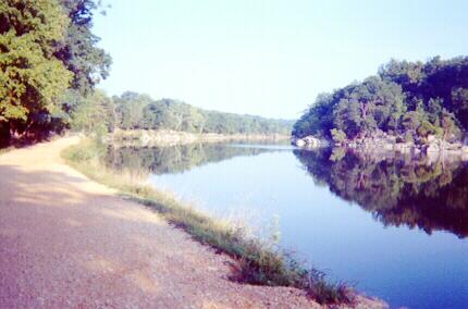
The C&O Canal Towpath is a 184.5-mile bike path running between Washington, DC and Cumberland, MD. In 2002-2003 I had great fun pedaling its entire length in three segments. The quest began in August, 2002 just before my classes began. We drove to northern Virginia, stayed overnight in Manassas on a Saturday night, and drove quickly on Route 66 to the beginning of the trail in Georgetown on Sunday morning. An early start was essential because by noon the temperature would be approaching 90 degrees with generous humidity. Immediately after crossing the Key Bridge into Georgetown we made a right turn next to the Francis Scott Key Park. No parking is allowed on this street, but it was early in the morning, and we were able to quickly unload my bike near the Ukrainian embassy. Within minutes someone came out of the embassy and told us to move the car.
My watch said 6:55 AM as I began pedaling at roughly the one-mile marker on the towpath. There was no sense trying to start at mile zero since that spot was inconveniently located. I carried three water bottles, two bananas, an apple, two cookies, some raisins, and a crummy waterproof disposable film camera left over from C’s disappointing Hawaiian snorkeling adventure. All this, along with my wallet, change purse, and eyeglasses fit in my belt bag and the pockets of my biking shirt!
It was a relief to begin the journey. I worried quite a bit before the trip about how long it would take and how rough the trail would be. It turned out to be no problem. The trail was in excellent condition, much better than the Virginia Creeper Trail. The towpath was fairly soft light-colored dirt, not too loose, and not too hard-packed. Some small gravel was mixed with the dirt, but more than 90 percent of the trail was flat, smooth, and a joy to ride. I hoped to be able to manage an average of ten miles per hour for the trip. When a trail is too rough, however, it can be an effort to maintain such a speed. Again, it was no problem, especially during the last half of the trip. When I rode further north on this trail, I didn’t worry so much beforehand.
 |
| Typical scene from early miles - smooth path with canal on right. |
 |
| Unattractive green scum mars beauty of the canal. |
 |
| A lock keeper's house. |
 |
| Another white lock keeper's house and lock. |
 |
| Scene approaching the "rocky breach". |
 |
| Rough path in the "rocky breach". |
 |
| The towpath became a shady country lane. |
 |
| The ferry named General Jubal Early crosses the Potomac at White's Ferry. |
 |
| Walking my bike over bumps on the Monocacy Aqueduct. |
 |
| Lovely shady woods. |
Harper’s Ferry was not far off now. I expected to see it around every bend. The miles continued to pass. Soon I could see people floating down the Potomac in inner tubes. That meant the journey’s end was coming very soon. I passed the 60-mile mark and knew there was less than a mile to go! I arrived at the base of the bridge to Harper’s Ferry at exactly 12:30 PM. It had taken 5 hours and 35 minutes to bike approximately 60 miles to this spot!
 |
| Endpoint of my ride beneath railroad bridges at Harper's Ferry. |
Our car was parked at the Harper’s Ferry Visitor’s Center about two miles away. C had taken a shuttle bus from the Visitor’s Center down to the town to meet me. No bikes are allowed on the shuttle bus. I foolishly suggested we walk back to the Visitor’s Center together. That was a mistake! The walking trip was much longer than expected. Although I biked 60 miles without too much trouble, this final walk nearly did me in! During the final mile I struggled to push my bike uphill in unshaded 90-degree humidity. By the time we got to the car I was completely exhausted and sweating heavily. It was a real effort to take the bike apart and load all of my equipment in the steaming car. Finally, I changed clothes in the restroom at the Visitor’s Center, and we drove off with air conditioning on maximum.
I'll share the second part of the story in my next post.
No comments:
Post a Comment